The Study
In 1870-72, John Marius Wilson’s Imperial Gazetteer of England and Wales described St Mary Bourne like this:
BOURNE-ST. MARY, a tything and a parish in Whitchurch district, Hants. The tything lies near the Southwestern railway, 3 miles NW of Whitchurch; and has a post office under Andover. Pop., 384. The parish includes also the tythings of Binley, Egbury, Stoke, Swampton, Jamaica, and Week. Acres, 7,678. Real property, £5,380. Pop., 1,188. Houses, 282. The property is much subdivided. The living is a p. curacy, annexed to the vicarage of Hurstbourne-Priors, in the diocese of Winchester. The church is good.2
St Mary Bourne and it’s surrounding hamlets have long been of interest to me and over the last 15-20 years I have gathered a large amount of data on the village and it’s inhabitants. My plan is to use this data to study of the village in more detail.
As my focus has always been the poor labourers of the village as it is those people from whom I descend, the initial focus will be on those involved in the Swing Riots of 1830. The time frame will be 1821-1841 enabling me to look at what was happening in the area before and after the riots.
The village Overseers Accounts, Parish Records, 1841 Census and Tithe Return will be the main datasets used.
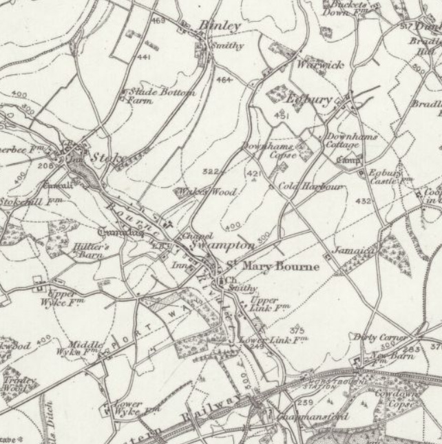
- Reproduced with the permission of the National Library of Scotland, https://maps.nls.uk/index.html, [accessed 17 October 2023] ↩︎
- GB Historical GIS / University of Portsmouth, History of St Mary Bourne, in Basingstoke and Deane and Hampshire | Map and description, A Vision of Britain through Time, http://www.visionofbritain.org.uk/place/4001, [accessed: 17 October 2023] ↩︎